What is 27 pages long and brimming with diagrams and design specs for village-like, clustered development? It’s the new commercial zoning bylaw proposed for Harvard’s commercial district, a 1.2 mile stretch of Ayer Road between the Route 2 interchange and the Ayer town line. Voters will have the chance to accept or reject it at the May 3 Town Meeting.
The bylaw was developed to improve the existing commercial zoning, which has been described in successive master plans and recent studies as outdated and conducive to suburban sprawl. Several years in the making, the proposed form-based zoning bylaw is the final piece of the “Ayer Road Vision Plan,” which outlines a development strategy for the corridor and features form-based zoning code as the way to achieve more appealing development and perhaps generate tax revenue.
The Ayer Road Vision Plan was compiled in three phases. Phases 1 and 2 determined the kinds of businesses people wanted and how they preferred the buildings to look; analyzed the market demand for retail versus residential uses; and estimated the impact of more development on tax revenue for the town. During phase 3, consultants who specialize in writing form-based zoning bylaws created the new zoning based on the “vision” derived from phases 1 and 2.
The two consulting firms that completed the plan between 2022 and 2024 arrived at two key conclusions. First, Harvard’s existing zoning is deficient and “can only lead to more spotty unattractive uses and undesirable development.” Second, according to fiscal analysis by both firms, it is not realistic to expect intensive commercial development on Ayer Road. The town’s demographics, its lack of municipal sewer and water, and the limited number of suitable parcels available for development or redevelopment make it economically infeasible.
Weitzman Associates, which conducted the first phase of the plan, concluded in its report:
“Our recommendation would not be to maximize the development of Harvard’s retail potential. We would rather recommend the incremental development of street-oriented retail as part of small-scale, mixed-use commercial and residential projects in clusters designed around the sustainable and smart growth principles of a village center arrangement.”
The follow-on phase 2 analysis by Boston-based planning and design firm Utile concurred: “Commercial developments carry significantly more risk [for developers] than residential. The planning team estimates developers will want to cap commercial uses at around 10% or less of the total development square footage.” More retail might be possible if the market changed or the town could “find the right tenant,” the study said. See Q&A: What to know about the proposed zoning for the commercial district” below.
Associated tax revenue?
Fiscal analysis from both consulting firms estimated that without water and sewer infrastructure, it would be difficult to create projects large enough to generate revenue for the town. On that the two firms agreed. But estimates of tax revenue were very different, perhaps because one was net and the other gross.
The Utile analysis imagined redevelopment scenarios for three “test-fit” sites on Ayer Road: small (1.5 acres), medium (4.7 acres), and large (9.6 acres). Using models that estimated “the potential cost of, and revenue generated through, the development of each scenario,” consultants calculated the financial viability of redeveloping each property with private water and sewer; public water and private wastewater; and public water and sewer.
Utile found that the development scenario created for the largest site—the business plaza at 285 Ayer Road—was the most likely to generate net tax revenue. And then, only if it had municipal water and sewer. The revenue was estimated at about $40,000 per year after subtracting the cost of school and other services. The development assumed a mix of 64% residential use, 10 units per acre, and 36% commercial use, including office, retail, restaurant, and lodging. This scenario was also deemed the only one of the three test sites that would be financially feasible for a developer.
On the other hand, estimates done in phase 1 by Weitzman estimated gross tax revenue for a similar-sized development at between $276,000 and $403,000. But those estimates used a $17.90 tax rate instead of the current tax rate, $14.89, the rate used in Utile’s estimate. Weitzman’s estimates also did not subtract the cost of services.
Reacting to the studies’ analysis, Planning Board Chair John McCormack observed that predicting tax revenue in future markets is clearly tricky. “We should recognize that both studies, approaching the subject differently, lead to observations that the town should benefit from the right kind of development.” The absence of form-based code, he said, “just means we may be facilitating an undisciplined and riskier model of development.”
Better zoning, better buildings?
But would adopting the new zoning really lead to better buildings? McCormack said he thinks it will provide greater “prescriptiveness and predictability” as to what gets built in the commercial district. He pointed to the voluntary nature of the town’s design guidelines as a problem that could be solved by enacting the new code.
Currently, the Design Review Board—a subcommittee of the Planning Board—uses a 30-page design document to review proposed projects in the district. But because the board and the design guidelines are advisory, developers are not obligated to accept the board’s recommendations, which are meant to ensure that the buildings blend with Harvard’s character. “We are making the design guidelines part of the code so they are no longer suggestions: They are requirements, and enforceable.” This would have been useful, McCormack said, during the permitting process for the 30,000-square-foot badminton facility currently under construction on Ayer Road. Under the new zoning, the maximum building size would remain at 30,000 square feet, but the badminton building might have been designed with less unbroken frontage.
Q&A: What to know about the proposed zoning for the commercial district
Q: What is form-based code?
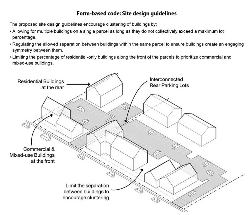
A: According to the Center for Zoning Solutions, form-based zoning codes prioritize the relationship between building facades and public places including walkways and plazas. Clustering of buildings, placement of windows, keeping parking lots in the back, and walkability are all important considerations. The VillageWorks, a two-story commercial development of retail, restaurant, and office uses on Route 111 in West Acton, exemplifies the kind of project this code aims to encourage.
Q: How is it different from the town’s current commercial zoning?
A: Conventional zoning such as Harvard’s sets parameters for development via detailed standards primarily keyed to use, emphasizing floor area ratios (FAR), setbacks, and parking ratios. This can lead to buildings that are not as appealing as they could be, often because FARs interact in unexpected ways with other dimensional requirements.
Instead of relying on fixed ratios, the new zoning specifies parameters with detailed diagrams and illustrations that prioritize the form and massing of the buildings.
Another difference is the new zoning’s specifications for mixed-use development. Current specs are ambiguous and incomplete, according to Planning Board members. The new form-based code would in almost all cases require any mixed-use building to keep commercial space on the first floor and living space on the second and third floors (three stories are the limit). It would also allow mixed use anywhere in the district, clearing up the current ambiguity. (The board has also proposed–elsewhere in the bylaw–a definition of mixed use: “a mixed-use premises is one with both commercial and residential uses in the same location.”)
Q: Will the form-based code replace the existing commercial zoning bylaw?
A: No, it will add to it, and according to Planning Board Chair John McCormack, make it more precise. Allowable commercial uses will still be listed in the bylaw. If a requirement imposed by the form-based code conflicts with those of the existing commercial zoning, the form-based code prevails.
Q: Would this new zoning allow big-box stores?
A: A prototypical big box, usually about 100,000 square feet, would not meet the standards set in the form-based code. Buildings that face the road can be up to 15,000 square feet; interior-facing buildings up to 20,000. Unbroken, windowless expanses, including rooflines, are not allowed. A building of 30,000 square feet would be possible by special permit, but a monolithic building wouldn’t meet the requirements of the bylaw. (See illustration, “Site design guidelines” below, which shows the shape and massing of buildings.)
Q: How many properties would the zoning affect?
A: According to the Ayer Road Vision Plan, the commercial district consists of 60 parcels, totalling about 344 acres; 28 parcels are commercially used. Seven parcels are undeveloped for a total of 23 acres. The district is 1.2 miles long.
Q: What is the allowed density in a mixed-use development and are there incentives for affordable housing?
A: Residential density under form-based code would be four units per acre in mixed-use developments. If at least 15% of units are affordable, density would be 10 units per acre.
—VH
Improved zoning and infrastructure: Will it bring mixed-use development or high-density housing?
Form-based zoning code is unrelated to the state’s Comprehensive Permit law, also known by its chapter number, 40B. But at the intersection of improved zoning and upgraded infrastructure, the topics mingle.
As the Ayer Road Vision Plan points out, municipal water and sewer are required for “meaningful” commercial development to take place, though infrastructure requirements are not part of the proposed commercial zoning. Still, plans to bring municipal water and sewer are already underway. Last month the state awarded Harvard a grant of $1.145 million to design a water and sewer for the 8-acre multifamily zone on Ayer Road. The zone was created by 2024 Town Meeting in compliance with MBTA Communities Act; it overlaps the commercial district and sits across the road from Dunkin’ Donuts. And, as noted on the Planning Board’s webpage introducing the Ayer Road Vision Plan, the plan’s development strategy “underscores the critical need for investment in public water and sewer infrastructure along the corridor to unlock its transformative development potential.”
Zoning Board of Appeals member Steve Moeser calls the proposed bylaw a “good attempt to control the outward appearance of buildings” in alignment with “New England architecture,” but asks whether residents have been “properly informed” about the impact of new infrastructure on the town.
“Would having sewer and water attract large-scale 40B development? A 40B development does not need to follow any of the proposed form-based code,” he said.
His concern is fueled by Harvard’s vulnerability to 40B developments, which are exempt from local zoning law. The town’s percentage of affordable housing is 5.6 % against the state-mandated 10%, leaving it 103 units short and unable to deny proposed 40B projects, according to Harvard’s 2024-2028 Housing Production Plan.
If the gating factor–lack of public water and sewer–to large affordable housing endeavors is lifted, Moeser asks, will developers be attracted to the possibilities for mixed use under the form-based code, or to the increased all-residential density allowed under 40B?
“We have been told that the town loses money on residential development,” Moeser said. He asked: “Were the long-term effects considered when developing this bylaw?” He said the town needs to be prepared for the possibility of increased residential development on Ayer Road and should start now by trying to estimate the costs of municipal services for schooling, police, fire, and elder services.
Planning Board Chair John McCormack acknowledged the concern but said voting against the new zoning won’t help Harvard’s affordable housing deficit, let alone solve Ayer Road’s inadequate commercial zoning. “This [form-based-code] isn’t going to be more attractive than 40Bs to developers bent on building them, but it is going to be more attractive than the existing commercial zoning.”
Town Administrator Dan Nason said there were “too many unknowns” to say how Harvard could prepare for the eventual construction of water and sewer on Ayer Road and the possible increase of 40B applications. “It is too early in the process,” he said.
—VH