
Harvard is known for its historic New England beauty, which is evident in its well-preserved town center and villages, winding country roads, and scenic vistas. The way Harvard looks and functions did not happen by accident—it is the result of a long history of townspeople approaching challenges in a thoughtful and deliberative manner, particularly those that involved land use and open space. Today, we have a new challenge because there is one district that appears incongruous with the rest of the town: the commercial district on Ayer Road from the Route 2 overpass north to the bend in the road at Doe Orchards.
Driving through the district, it appears that each development seems disparate and disconnected, without any kind of unifying theme reflecting Harvard’s sense of place, community, or character. Indeed, Harvard’s current land-use regulations have had the unintended effect of promoting strip development with deep setbacks and parking located in front of the buildings.
Zoning is perhaps the most important tool communities can use to shape the pattern of development because it can be used to either facilitate this kind of undesirable sprawl or prevent it from happening or expanding. Proper ordinances can address more than just permitted uses, lot sizes, and setbacks; they can also help facilitate better architecture, landscaping, signage, and parking unique to the commercial district. Just as with other parts of our built environment, good planning can work to ensure higher-quality development that is visually attractive, is compatible with safe traffic flow and pedestrian access, and yields greater tax revenues.
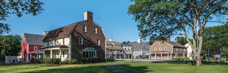
An example of good design in Sudbury. (Courtesy photo)
Not when but how
With so many parcels currently for sale in the commercial district, the area will be developed in the coming years, but how is the central question. The Planning Board thought it was better to be proactive in shaping a new vision for the district that would meet residents’ demands for smaller-scale retail development that would provide some needed services but would also recognize their legitimate concerns about safety, traffic congestion, noise, and light pollution. Along with guiding the aesthetics of new design, it was equally important to find ways to mitigate potentially negative impacts so that any new development would be a net positive for the town—particularly for residents who live in the surrounding neighborhoods.
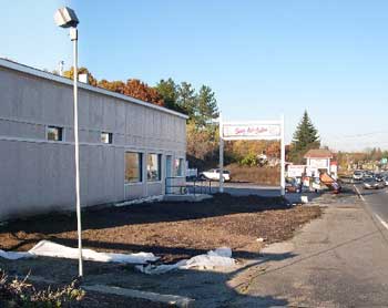
An example of the type of development the town would like to avoid. (Courtesy photo)
To that end, the Planning Board formed the Commercial Design Standards Task Force (CDSTF) to research the best practices employed by other towns to create a comprehensive plan for new commercial development. The CDSTF was led by Planning Board member Erin McBee and comprised other residents who had specific professional experience in architecture, commercial development, real estate, landscape design, park and recreation management, and economic development.
The commercial district is only about 346 acres, but around 13,000 cars travel the Ayer Road corridor daily while just under 50,000 cars pass the Route 2 interchange.
Responding to the vision residents have articulated in numerous public meetings and surveys, the CDSTF sought ways to slow traffic down; encourage distinctive architectural features; create safe walkable connection points between residential, commercial, and recreational spaces; and integrate adjacent commercial parcels.
A new framework
The CDSTF devised a new framework for development that—over time—would lead to a commercial village that would look more like a smaller version of West Acton center or Concord center. With buildings located closer to the road, fewer curb cuts, the establishment of crosswalks, sidewalks, and other traffic-calming measures, traffic along Ayer Road would be forced to slow to a reasonable speed and tractor-trailers cutting through to Devens would be effectively discouraged. Although recreation areas, restaurants, and medical offices exist today in the C-district, virtually no one accesses these services by walking to them because of the danger Ayer Road currently represents. Imagine a more walkable commercial district where neighbors could meet at the playground, seniors could walk to get a cup of coffee, and kids could safely get to the soccer fields for practice.
Developers would also benefit from design standards. Promulgating guidelines that communicate the town’s preference for design of commercial projects would help architects and engineers work more efficiently with Harvard’s land-use boards. Deciding on the general site and architectural parameters early in the process would preclude expensive revisions to final plans that require modification to conform to local boards’ decrees. Designers could present their project with a reasonable expectation that compliance with accepted principles would have a greater likelihood of approval, leading to a less stressful review process.
A few important zoning amendments are necessary to remove barriers to achieving this vision. Harvard has one set of dimensional standards that apply to all districts. These have worked well for preserving the rural, low-density character of Harvard’s residential district, but they will serve to perpetuate the strip-commercial nature of the C-district if left unchanged. Three zoning amendments are on the agenda for the Annual Town Meeting:
- Reduce the front setback to 20 feet from the front lot line. The current large front-setback requirement in the C-district results in buildings placed far from the road, allowing parking to be highly visible from the street. Bringing buildings closer to the road will allow for sidewalks and a green buffer strip to begin to establish a “Main Street” composition for the C-district.
- Reduce the side and rear setbacks to 20 feet. Large setbacks in residential areas help to assure privacy from abutters, but the same standards result in commercial buildings standing in isolation from their neighbors. The smaller setbacks would bring buildings closer together and improve pedestrian and vehicle connectivity.
- Lower the “green area” requirement to 50 percent of the lot area. An excessive open space requirement hinders sound site planning by constraining the developable area of a lot. The reduction would still allow for generous open space but help achieve better utilization of the limited acreage in the district.
With much of the C-district for sale, the time to act is now. Without rising to the challenge, we’ll have more of the same strip development, but with perhaps larger, irreversible, unintended outcomes. With a new comprehensive strategy for the C-district, new projects and redevelopment can achieve the vision residents have consistently expressed: a commercial zone that enhances the livability of the town while providing a more diversified tax base—serving the best interests of both homeowners and business owners along Ayer Road as well as residents throughout Harvard.
Kara Minar is chair of the Planning Board; Bill Scanlan is Harvard’s town planner.