
In light of the current traffic studies on town center and sections of Ayer Road, now is a good time to look back at the traffic concerns that plagued our predecessors.
I imagine traffic jams happened frequently on the Common in the early days. Going from north to south, you could easily get wiped out by a couple of cows, eager for the tall grass across the way. With a tree blocking your line of sight, you could run your wheelbarrow right into an oncoming neighbor. So many footpaths crossed the Common that it would have been hard to know who had the right-of-way. The traffic headaches must have been greatly alleviated in 1804, when horses, swine, and cattle were kicked off the Common. The cart paths around the Common were still treacherous because animals weren’t restricted from running loose on the “highways” until six years later.
It’s hard to look at the facts of Harvard history and not wonder about some of the what ifs. And for traffic, those are pretty scary and should give us some perspective on our current problems. In 1804, Colonel Henry Bromfield founded the Union Turnpike, a corporation with 20 investors. The road was envisioned as a link between the Cambridge and Concord Turnpike to the east and the Fifth Massachusetts Turnpike, which began in Leominster, to the west.
The new stretch, a toll road, would complete the highway from Boston to Albany. The Union Turnpike came from the east down Woodchuck and Oak Hill, through the center, down Still River Road to Madigan Lane, up over Prospect Hill, into the river meadows, and on through Lancaster to Leominster.
What if?
The corporation dissolved in the early 1820s because of competition from other routes. But what if there hadn’t been other good routes? I, for one, would be living on a major thoroughfare. (Oh, wait. I wouldn’t have bought the house.) As it was, “my” part of the Union Turnpike remained busy. Until 1895, when the state put in Route 111 through the center, there was no road past the Bromfield School. Travelers going east had to use Oak Hill and Woodchuck Hill roads.
A closer call came in the late 1940s when the state proposed a highway through the center of Harvard. One scenario was to follow Route 111 from Boxborough and then pass along the southern shore of Bare Hill Pond. Imagine that traffic jam while parents are trying to drop off elementary school children. How many eyes would ogle us (or not) in our bathing suits as cars sped westward? Fortunately, the town’s voice was heard, and the state moved Route 2 north of the town center.
There was no need for strong opposition when Route 495 came through Harvard.The plan from the beginning was for it to go through a sparsely populated swampy section in the southeast section of town.
Surprisingly, the idea of a rotary at the intersection of routes 110 and 111 has historical precedent. The Historical Society has a metal stand with “Go Right” on each of its “wings.” Its size of about 2 feet and its light material suggest it was put out temporarily for high-volume traffic. A picture shows it in the roadway as caissons of supplies from Fort Devens move through Harvard center.
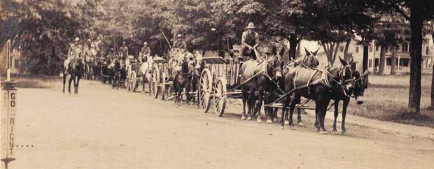
At the center of town, a rotary (far left) directs wagons loaded with supplies from Fort Devens in World War I. (Photo courtesy of the Harvard Historical Society.)
Common terms for Common lands: A glossary
Currently, much discussion around town is focused on possible changes to the center—expansion of the historic district, a new traffic pattern, reuse of the old library, parking, and more. It seems useful to clarify places and terms connected to these discussions so that everyone agrees on the historical terminology, if not the substance of the debated issues.
The Little Common: Contrary to the opinion of most everyone who doesn’t live around it, the Little Common is not the triangle on the east side of Ayer Road on which the Civil War memorial stands. That land is just one of the smaller pieces of the (big) Common. (It would be nice to name it. Maybe “Memory Triangle,” after the female figure strewing flowers in remembrance of those lost in the war.) The real Little Common is a triangle that lies between Oak Hill Road and Fairbank Street on the way to the back of Hildreth Elementary School. It has no statue, but it does have a giant sycamore, perhaps as old as Memory. The Harvard Center Historic District, established in 1973, was later expanded to include the houses around the Little Common and short distances up Oak Hill and Fairbank.
Nameless Roads: There are two paved roads in the center that have no street signs giving their names. They are the equidistant and parallel roads that form the north and south borders of the detached piece of the Common east of the General Store. (Evergreen Square?) The southernmost road appears in records of 1945 as Common Street. The other road extends from the end of Still River Road at the blinker to where the road meets Fairbank Street. It is not part of Old Littleton Road, which is described in old records as ending at Fairbank. The Still River Extension? North Common Street?
Open Space: There is some confusion about who owns two small parcels of open space, one to the south of Common Street and the other just west of the General Store. The town owns the latter, and it is under the jurisdiction of the Parks and Recreation Commission. That land between the store and the Congregational Church was left open after 1905 when the town sold its Center School building to Ayer. The other piece of land was made vacant in 1917 after two stately homes were lost to a fire. The Conservation Commission has authorization over this space.
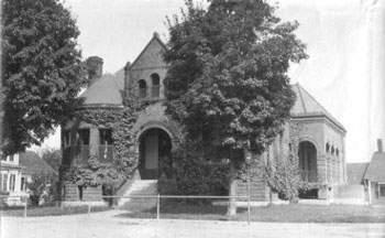
Harvard’s library in 1902, just after the Hapgood addition was added. (Photo courtesy of the Harvard Historical Society)
Harvard Public Library and the Hapgood Memorial: It is a historical inaccuracy to call the old library the Hapgood Library. The Harvard Public Library was dedicated in 1887; the Hapgood Memorial was dedicated in 1904 after a bequest from Warren Hapgood two years earlier made possible a large addition to the east side of the building to house the children’s room and a large downstairs meeting room.
Historic; historical: The word “historic” refers to momentous events in the past: “The March on Selma was a historic event.” “Historical” is used to refer to general things in the past: “Historical information was collected from the archaeological dig.” But, this being the English language, of course there are exceptions. We use “historic” when referring to districts and houses. Thus, the Historical Commission deals with historic homes and historical evidence.
Monument; memorial: A monument is a tribute to a person or special event. Its usual intention is to celebrate the positive. The Washington Monument, while memorializing a dead person, is more a tribute to the ideals of the first president. A memorial is a remembrance of someone who died. The connotation is that we want to remember the tragedy so as not to repeat it. Our Civil War statue is a memorial.
— Carlene Phillips